UNESCO/Toson-Khulstai Biosphere Reserve
Agua y Paz
General information
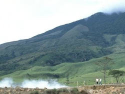
The Agua y Paz (Water and Peace) Biosphere Reserve is characterised by mountain ranges and plains. In the mountainous zones are the volcanoes Miravalles, Tenorio, Arenal, Chato and Platanar, among others, and in the plains area are lakes, flooded forests and swamps, some of which are Ramsar sites, such as Lake Caño Negro.

Detailed information
Key data
Year of nomination
2007
Country
Costa Rica
Total population
503960
Area
Surface
916,121.00 ha
Total terresterial area
916,121.00 ha
Location
Latitiude: 10.75 - Longitude: -84.75
Contact
Ecological Characteristics
The reserve is comprised of eight core zones that are protected wildlife areas legally constituted in the country and that are administered through the National System of Conservation Areas (SINAC). This agency divides the country into 11 conservation areas, of which three are included in the Agua y Paz Biosphere Reserve, these areas are: the Arenal Huetar Norte Conservation Area (ACAHN), the conservation area of the Arenal-Tempisque Biosphere Reserve (ACAT), and Cordillera Central Volcanic conservation area (ACCVC) .In addition to this administrative division, Costa Rica is politically divided into Provinces, which are divided into Cantons, and these in turn Districts. The Biosphere Reserve completely covers the cantons of Los Chiles, Guatuso, San Carlos and Alfaro Ruiz, and partly the cantons of Upala, Grecia, Sarapiquí, Tilarán, Cañas, Puntarenas and Montes de Oro.
Socio-Economics Characteristics
The estimated population in the territory covered by the Biosphere Reserve is 299 350 people representing about 7% of the total population in Costa Rica. Of this population, the vast majority is considered a rural population.